Case Study

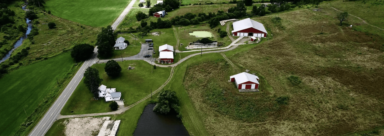
Tioga County, Pennsylvania
Tioga County, located in north-central Pennsylvania, was known for its lush forests and a landscape of hills and valleys. The County Assessment Office worked hard to maintain a set of hard-copy tax maps to support assessment operations, which were crucial for real estate developers, hunters, and oil and gas companies who relied on accurate property boundary data for their daily operations. However, the County also maintained an obsolete and inaccurate parcel GIS layer, which complicated the efficiency and accuracy of property-related decisions; thereby creating challenges in integrating new data with existing systems.
At a glance
A few years ago, Sidwell completed a project for Tioga County, PA, reconstructing a new countywide layer of 26,000 parcels from original source land records. Since then, the county has seen significant improvements in data accuracy and operational efficiency.
Seeking a More Efficient GIS Solution
In the years leading up to the project, GIS Coordinator Scott Zubek and Chief Assessor Josh Zeyn had been encountering numerous challenges from the fact that their existing tax maps were inaccurate. Their office received many calls about inaccurate parcels from the typical groups that always rely on such data, including real estate developers, hunters, and other researchers. Due to the Marcellus Shale boom, they saw increased activity from Oil & Gas companies doing a lot of property boundary research. Data quality issues with the parcel data also made it highly problematic to display them on a public-facing GIS web application. Accurate and complete parcel data was an absolute requirement to support the implementation of a new CAMA system in the Assessor’s office.
Additionally, they required a solution that would align with the state’s Clean & Green program and support a countywide reassessment, including calculating the acreage of each soil type based on accurate parcel boundaries and executing a slope rating analysis by processing resultant soil and parcel data with LiDAR-derived 3D models.
The county sought an ultimate solution that could collect and display accurate, up-to-date parcel data, reduce the number of calls to the office, and free up staff to focus on more critical tasks. Enhancing operational efficiency and improving the customer experience were top priorities.
The Right Solution: The ArcGIS Parcel Fabric
As a joint effort, Sidwell and Tioga County collaborated on a case study to assess the county’s system and determine the best solution for its needs. Through this assessment, Sidwell confirmed several reported issues, including parcels incorrectly associated with houses or lots, which had led to errors in delinquent sales. Recognizing the need for improvement, the county moved forward with Sidwell’s proposed countywide solution—Esri’s ArcGIS Parcel Fabric. Together, they utilized original source documents, including recorded survey data with geodetic coordinates, and delivered data in the latest version of Parcel Fabric, enabling the county to visualize and experience accurate parcel data seamlessly aligned with their CAMA system.
During the course of the project, Sidwell incorporated over 60,000 documents, including recorded surveys, plats, historical maps, legal documents, and over 2,500 GNSS control points. These materials were essential in accurately mapping parcels and establishing a framework for those parcels across the county. The newly constructed countywide parcel layer was delivered as an ArcGIS Parcel Fabric dataset compatible with Tioga County’s Enterprise GIS environment, and Sidwell ensured that the Assessor’s office received comprehensive end-user training.
The Results
The project and ArcGIS Parcel Fabric resulted in a significant improvement in Tioga County’s data quality and accuracy. The history of parcels misaligned with houses and lots was resolved, preventing future errors in property sales. With more accurate public-facing data, the county experienced a reduction in phone traffic, which allowed staff to focus on other critical tasks. Additionally, the streamlined day-to-day parcel maintenance has increased overall efficiency. The improvements in data accuracy not only reduced the workload for the county office but also increased the public’s confidence in the data provided.
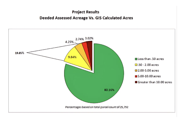
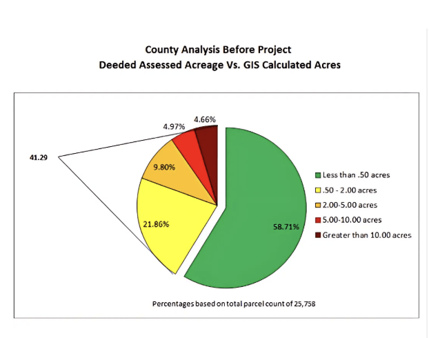
Tioga County performed a commonly used quality control Parcel Acreage Validation estimate and noticed striking results, even in the initial assessment. The accuracy improvements were quantifiable—the percentage of parcels where the mapped acreage matched the deeded acreage (within 0.50 acres) rose from 58% to 80%. Currently, 90% of parcels are within 2 acres of the deeded acreage in the CAMA system.
Regarding the countywide reassessment of soil and land use types, the accurate parcel boundaries have ensured more precise calculations. The county also began a slope mapping project, identifying parcels with a slope of 25% or higher as unbuildable—a process made possible by accurate parcel data.
Additionally, accurate mapping ensured that reassessment field staff were visiting the correct properties, improving the efficiency of property visits.
Zeyn presented these findings in a letter to the County Commissioners, and they agreed that the project was a success with tangible operational benefits that justified the investment
Tioga County’s Success
By partnering with Sidwell, Tioga County was able to identify and address the needs of its residents and businesses, make its office more efficient and improve customer satisfaction. The real-world consequences of inaccurate parcel data can be significant, so ensuring it is accurate, timely, and easily accessed by the public is essential.
To learn how Sidwell can enhance your parcel management systems, reach out to info@sidwellco.com