Geographic sections to large custom aerials of towns, villages, townships, and counties are available in varying years for the following 27 states:
Specialty maps include our collection of the hand-crafted Chain-O-Lakes District Map, aerial photography, and scenic aerials. Contact us with additional questions about these specialty maps using the form below.
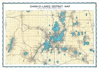
In 1956 our founder, Joe Sidwell, hand-drafted a Chain-O-Lakes Illinois District Map. This reproduction is available exclusively through Sidwell.
Chain-O-Lakes was officially designated a state park by the State of Illinois in 1945. Located in both McHenry and Lake Counties, in the northeastern corner of Illinois, the park boasts nearly 6,500 acres of water and 488 miles of shoreline — a major water recreation area.
The district map portrays the area around 1956 and this color reproduction presents a classic and historic snapshot of that time.
Geographic sections to large custom aerials of towns, villages, townships, and counties are available in varying years for the following 27 states:

Alaska, Alabama, Arkansas, California, Colorado, Georgia, Iowa, Illinois, Indiana, Kansas, Maine, Michigan, Minnesota, Missouri, North Carolina, North Dakota, Nebraska, New Mexico, Nevada, Ohio, Oklahoma, Pennsylvania, South Carolina, Texas, Utah, Washington, and Wisconsin.
Sidwell has an extensive library of scenic aerials that are available in many sizes and are ready for framing. For a listing of available images, sizes, and pricing, please contact us.
Copyright © 2026 The Sidwell Company. All rights reserved. | Privacy and Attribution Information.


