

From Scanned Plats to Parcel Fabric-Ready Records, Powered by AI + Human-in-the-Loop
MTerra is an innovative AI + human-in-the-loop service that turns scanned plats, historical maps, and new development records into validated, ArcGIS Parcel Fabric-ready parcel data with machine speed and survey-grade confidence.
For decades, counties have had only two options for converting cadastral records, and neither one works at scale.
[ × ] Pure manual digitization
is accurate but slow, labor-intensive, and impossible to sustain against a growing backlog.
[ × ] Pure automation
is fast but unreliable on real-world plats. Faded scans, handwritten annotations, inconsistent survey methods, and legacy coordinate systems break traditional tracing tools and introduce errors no one catches.
MTERRA’S BREAKTHROUGH IS TO COMBINE THEM
AI does the heavy lifting; Sidwell’s experts make the call.
Purpose-built AI models read each record the way a cadastral expert would: detecting boundaries, lot lines, COGO values, bearings and distances, parcel numbers, symbols, and text, and flag anything uncertain. Sidwell’s experts then review, correct, and confirm, so nothing reaches your Parcel Fabric on the strength of a machine guess alone. Every result is finished with COGO validation, least-squares adjustment, coordinate alignment, and geodetic checks.
The result is genuinely new: machine speed with survey-grade confidence. Counties clear backlogs and keep pace with new development without trading away accuracy, traceability, or defensibility.
How MTerra Works
Upload
The county provides scanned plats, historical maps, PDFs, current field sketches, or new subdivision plats.
AI-Assisted Extraction
MTerra detects boundaries, parcels, lines, points, symbols, text, COGO values, and attributes from the source record.
Cadastral Review
Analysts review flagged items, correct missing segments, verify parcel logic, and confirm the record.
Adjustment & QA
COGO validation, least-squares adjustment, coordinate alignment, edge matching, and geodetic verification.
Parcel Fabric-Ready Delivery
Verified parcel records are delivered ready for ArcGIS Parcel Fabric.
MTERRA IN ACTION
A real subdivision plat, end to end
From scanned paper to production-ready parcels.
STEP 01: UPLOAD
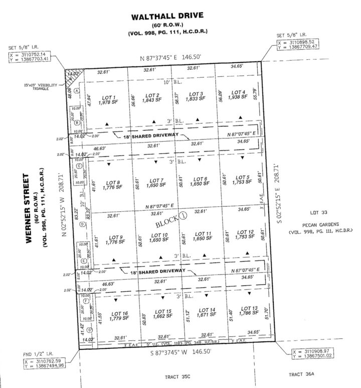
Start with the scanned plat
Thousands of subdivision plats exist only as paper archives. A county uploads the scanned image, with no pre-processing and no manual prep.
SOURCE · scanned subdivision platSTEP 02: AI VECTORIZATION
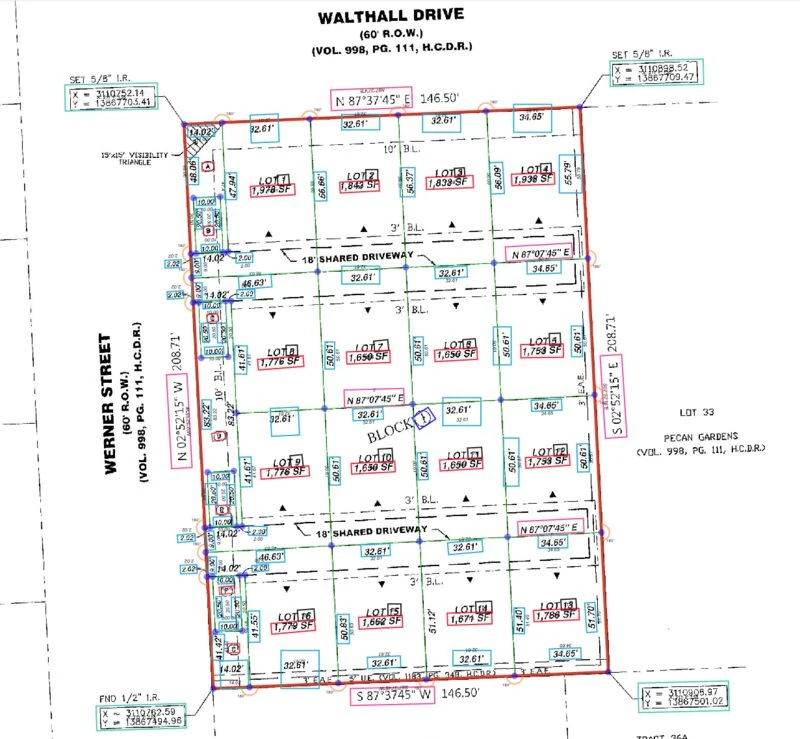
AI detects every feature
Computer vision classifies boundaries, lot lines, points, textboxes, and COGO values automatically, flagging anything it is not sure about for review.
DETECTED · boundaries · lines · textboxes · COGO
STEP 03: HUMAN-IN-THE-LOOP
Experts review and correct
Sidwell’s GIS experts resolve flagged items, including missing segments, undetected origins, and unreadable values, directly in the editor before anything is committed.
RESOLVED · origin · line · textboxSTEP 04: ADJUSTMENT & QA
Adjusted to the legal record
A least-squares cadastral adjustment aligns geometry to the legal plat dimensions. Legal values are the source of truth, never inversed from geometry.
QA · least-squares · F-test · W-test

STEP 05: PARCEL FABRIC
Appended to production Parcel Fabric
Output is delivered as an LADM-conformant File Geodatabase and appended to the authoritative ArcGIS Parcel Fabric with COGO dimensions, bearings, and stated areas.
OUTPUT · ArcGIS Parcel Fabric · production-readyCAPABILITIES
Everything needed to build Parcel Fabric-ready records.
AI-Assisted Vectorization AI
Converts scanned plats, field sketches, maps, and raster records into vector parcel data.
Boundary & Line Detection AI
Detects parcel boundaries, connected lines, points, and geometry from image-based records.
COGO & Measurement Extraction AI
Extracts distances, bearings, and curve attributes used in cadastral reconstruction.
Parcel & Attribute Detection AI
Identifies parcels, lot numbers, labels, and related attributes from the source record.
Symbol & Text Recognition AI
Reads map symbols, text boxes, and annotations needed for accurate review.
Human-in-the-Loop Review HUMAN
Keeps trained analysts in the workflow so every record is verified, not simply machine traced.
Least-Squares Adjustment AI
Reduces measurement discrepancies and improves consistency across parcel geometry.
Coordinate Adjustment & Edge Matching AI
Aligns parcels with accepted coordinate systems and adjoining boundaries.
Parcel Fabric-Ready Output OUTPUT
Verified parcel records delivered ready for ArcGIS Parcel Fabric.
Benefits
By the Numbers
Processing time per subdivision, vs. days of manual work
Estimated reduction in processing cost
Geometry 100% true to legal records
Why It Matters
A genuinely new approach: AI + human-in-the-loop replaces the old choice between slow manual digitization and unreliable automation, delivering machine speed with survey-grade confidence.
Collapses processing time, from days to minutes: What took a skilled analyst one to several days per subdivision is completed in minutes.
Cuts cost by an estimated 80–90%: AI-assisted extraction turns days of manual digitization into hours of review, clearing backlogs at a fraction of the labor cost.
Accuracy, 100% true to legal records: Dimension-driven geometry adjusted to within the tolerances of the legal plat dimensions, with F-test and W-test quality checks.
Clears historical backlog: Process older plats, scanned records, and legacy cadastral maps efficiently, systematically working down thousands of undigitized plats.
Supports active development: Move new plats, subdivisions, and parcel changes into GIS faster, before they become the next backlog.
Improves parcel data quality: Automated COGO extraction eliminates manual-entry errors; least-squares adjustment and human review improve reliability and consistency.
Strengthens defensibility: Traceable validation produces parcel records that can be reviewed, traced, and defended.
Frees skilled staff: Analysts move from repetitive tracing and data entry to review and higher-value work.
Supports Parcel Fabric modernization: Delivers structured, validated parcel data ready for ArcGIS Parcel Fabric workflows.
WHO IT’S FOR
Built For Your Teams
GIS Directors
A practical way to reduce parcel backlog and support ArcGIS Parcel Fabric adoption.
Parcel Fabric Teams
Validated parcel data that’s cleaner before it reaches production.
County Assessors
More reliable boundaries for assessment, ownership, and tax workflows.
Planning Departments
Better visibility into new subdivisions, growth areas, and planned development.
Land Records Teams
A faster path from recorded plats and sketches to usable GIS data.
Survey & Cadastral Teams
Support for COGO values, legal dimensions, coordinate checks, adjustment, and geodetic validation.
Why Now?
Parcel data isn’t static. Counties are managing old records and new growth simultaneously, and the gap only widens with time. The tools that created today’s backlog can’t clear it: manual digitization is too slow, and automation alone isn’t reliable enough to trust. AI + human-in-the-loop is the first approach built to do both at once, clearing the historical backlog while keeping pace with active development in a single workflow, so land records, assessment, planning, permitting, and public GIS all draw on parcel data they can trust. The time to adopt it is before today’s new plats become tomorrow’s backlog.
Put AI + human-in-the-loop to work on your parcel records.
MTerra is available through Sidwell, your trusted partner for parcel and GIS modernization. Let’s talk about clearing your backlog and keeping your parcel system current with the speed of AI and the confidence of expert review.
Contact Us Today. Trust your data in the hands of an industry leader.