Much of Fulton County’s GIS was developed on legacy Esri ArcInfo technology and open source solutions. Existing staff had coupled these solutions with multiple, automated workflows to best serve the needs of the County to that point. Additionally, many staff were considering retirement packages being offered by the County and administration needed to secure their institutional knowledge and modernize solutions and implement best practices.
One of the most significant issues Sidwell found was that their cadastral data was often misaligned with aerial imagery and substandard mapping procedures were used for data entry. Land record documents often took several months to be processed, forcing local municipalities to implement their own parcel maintenance routines. This, in turn, allowed multiple, redundant datasets to exist for the same geography.
Furthermore, since Fulton County was using legacy Esri solutions, they were always finding workarounds for their daily workflows as tools and automated routines would “break” on a daily basis. Staff were holding on to procedures to which they were very accustomed. Managers and administrators were realizing that after pending staff retirements, no one would be around to troubleshoot these procedures, workflows and solutions. Although they knew that it would be a significant effort, they realized it was time to modernize or their operations would fail.
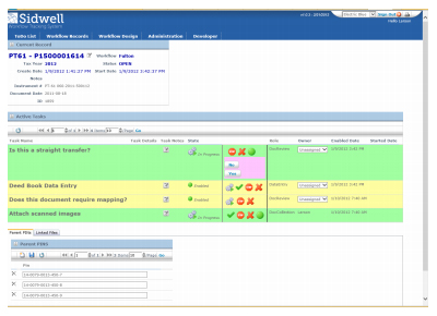
Fulton County’s Workflow Tracking System
Part of Fulton County’s automated workflow was to take the hundreds of individual legacy Esri Coverage files and append them into a countywide file and transform them into a countywide Shapefile for deployment and publication. While discussions were ongoing and government procedures for procurement took place, the County had to abandon the legacy solutions and survive without their automated workflows and legacy procedures.
The County was already in discussions with Esri to modernize their enterprise GIS platform. However, their land records (parcel) maintenance environment was the remaining legacy solution from which they knew it would be hard to transition. After their initial research at conferences, and through discussions with Esri representatives and other leaders in the industry, County staff approached Sidwell to learn more about their products and services for modernizing GIS-centric land record workflows.
Sidwell began with a very involved workflow analysis to learn what Fulton County’s needs and issues were, performed a high-level demonstration of our solutions and how they would fit into and improve upon county workflows, discussed the County’s needs for improved data accuracy and content, and highlighted numerous projects where Sidwell had completed similar enhancements and modernization projects. The recommendations revolved around getting the land records workflow into the most current GIS platform from Esri. This would leverage and extend the County’s existing investment with Esri and make operations more reliable and easier to administer.
With the upgrade in platforms, parcel maintenance workflows needed to be revisited because of the highly customized environment in which staff were working. In addition, Sidwell identified several manual and labor intensive workflows where modern solutions would greatly benefit their operations. Sidwell recommended their industry leading Parcel Administrator solutions to better manage the County parcel number inventory, parent-child genealogy, one-to-one and one-to-many parcel number relationships, real estate document tracking and assignment, and generation of hard copy maps.
In addition to Parcel Administrator, Sidwell implemented their Workflow Tracking System (WTS), which is a web-based intranet portal where users can digitally track documents through the land records system and enforce work being performed along each step of the workflow. WTS is a fully-configurable solution for tracking land records changes that integrates with Parcel Administrator by processing recorded documents, identifying parent parcels, and assigns tasks to data entry, mapping, and quality control managers for processing land records. By implementing this solution, it automated their workflows and enforced workflow steps.
Finally, Sidwell recommended that the County convert from their legacy Esri coverage data format and into a modern Geodatabase for better management to achieve a highly streamlined maintenance environment and easy deployment and publication (both digitally and hard copy) environment.
Sidwell also recommended value-added end-user training so staff could quickly get up-to-speed with the enhanced data, modern GIS software and streamlined workflows. Because of this partnership, Fulton County now has one of their key maintenance workflows embedded into their enterprise GIS plan. They have streamlined their parcel maintenance operations, shortened the lifecycle of document processing, and easily deploy their data across their jurisdiction and to the public.
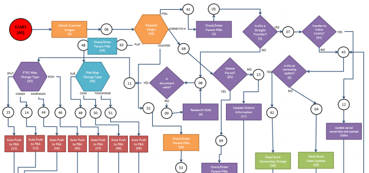
Workflow Tracking System Diagram created by Sidwell