The sessions showcased our client implementations and offerings to provide an overview of our imagery, mapping, and GIS-centric solutions. Mel Obbink led a session called GIS Geek Speak to ensure that everyone understands the many terms and acronyms that are used in GIS.
 Bill Wetzel demonstrated how clients can extend the reach of their GIS through the deployment of Esri’s Local Government Information Model (LGIM). Also discussed were several maps and applications that tie in to the LGIM, as well as Sidwell’s Portico GIS-centric web viewer. Portico allows users to view spatial and attribute data through an open or secured website. Imagery, various data layers, and attributes can be toggled on and off to enhance the user’s experience. Other data and external sites can be linked or integrated into Portico, i.e. county online tax payment site, photos of houses or sketches, property record print offs, and oblique imagery from Pictometry.
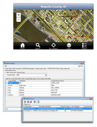
Using GIS for agricultural assessment calculations is a great method for generating consistent and accurate valuations. For many years, Sidwell’s Farms solution has been used to assist clients in performing agricultural land calculations. Mel presented an overview of the Farms application, which is an extension to Esri’s ArcGIS for Desktop. Farms uses two or three primary GIS layers: parcel, soils, and land use, to generate agricultural land calculations. In several counties, clients use an agricultural land use layer to better define the assessment of a parcel based upon its productivity. Farms can be configured to manage these and others layers to best support a county’s workflow. Farms also handles discrepancies between measured and deeded acreages, comparisons of soils types and values, and the exporting of values to a CAMA or tax administration system.
Mel showed users how to better visualize data using GIS, through the use of thematic maps, specific symbology, searches, and queries. Mel demonstrated how to join external attribute data from CAMA or tax administration programs to GIS data. Several benefits of visualizing data include validating data and codes, verifying property characteristics, analyzing property values and sales, and tracking the status of inventories or field operations.
The final session of the day outlined Sidwell’s partnership with Accela and highlighted the Accela Civic platform for managing permits, inspections, assets, service requests, and code enforcement. The Accela Civic platform is a cloud-based solution that can be accessed through any device. Accela has specific applications for office operations, citizen engagement, and field operations.
A special thank you to the Bismarck Comfort Inn for their hospitality, Mitch Frietas from Accela for providing giveaways to attendees, and to Dawn Caravallo from Esri for sending a wide array of Esri press books and other items.