Joyce West, GIS Manager
When a new GIS project is to be initiated for local government, it is common to analyze the existing information infrastructure. Often times this is the most important component towards implementing a new GIS. This provides a good time to scrutinize the systems that are in place and analyze how the new GIS project will fit in and how to take the best advantage and leverage this new system. The analysis may also include the hardware components such as desktop, server, network, and even mobile devices. The analysis should also review existing systems such as tax, CAMA, permitting, and asset management for data integration. Introducing a new GIS project will (and should) impact the way local government does business, so analysis of the workflow(s) are important.
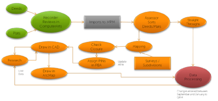
Before any data is edited, viewed or analyzed it is important that a thorough review of the flow of data and documents among the offices and departments takes place. Questions are asked such as: What is the path and process to record a new subdivision? What offices are involved? What pieces of data are gathered by different departments and how is that data retained? How is the new data accessed by other departments and the public? This analysis process helps to best define a new GIS implementation and leverage the functionality that GIS enables.
Now, how about using this process for an existing, mature GIS project? There’s likely some benefit to taking a step back to take a fresh look at the flow of information. What has changed since the GIS project was implemented? Very likely there are new systems and technologies that have been introduced, new responsibilities for local government offices, new data and reporting requirements. For many agencies the GIS and associated workflows were established years ago, and as the pace of technology has changed, many of these workflows have failed to keep up.
It’s quite possible that a GIS tune-up is in order! Think of it like maintaining your car with oil changes and tire rotations, or going to the doctor or dentist for a check-up, or even like cleaning out your desk. The GIS database may need a check of its geometry, topology, annotation, or indexing. Is everything in good order and running smoothly? The GIS tune-up reviews your workflow to identify new data that is being collected and processed and how GIS may be involved. Taking a fresh look at GIS interaction with newer systems may uncover opportunities for systems synchronization to visualize data and use spatial analysis. The GIS tune-up may suggest better ways to deliver information to the end user at their desktop, on the web, or via a mobile device. It’s time for a GIS tune-up to get the most out of your investment in technology.
Sidwell professionals will access:
- Land Management Workflows (Parcel, address, and permit integration points)
- Document tracking throughout the organization (Document “turn around” time frames)
- Use of technology and software
- Best use of communication channels