 Sidwell has become a leader and innovator in providing GIS services for address management and 911 mainly out of necessity for our clients. Several years ago, Sidwell discovered that many of our rural mapping clients expressed interest in starting a GIS for E911 department. We discovered that the mapping data in these departments wasn’t nearly as robust and usable as in the Assessor’s office. In many cases, it was just a centerline with associated attribute data, which some call a “stick map”. Created through a variety of projects or using free data that was acquired over the years, our clients didn’t realize the many benefits that could be gained by having reliable, comprehensive data. Through partnership with our clients we were able to utilize the first critical component towards creating these systems, the Assessor’s parcel and ownership data. Next, we set out to find a business partner that was an expert with this department, and one who valued the GIS data. After consulting with Esri, we knew that Bullberry Systems was the perfect fit for our clients.
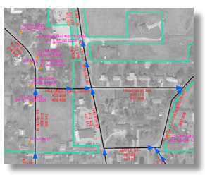
The Sidwell and Bullberry partnership has developed into a beneficial partnership for our county and municipal clients. By utilizing Sidwell’s Address Manager to maintain and build the GIS data and Bullberry’s Insight routing software and industry knowledge, an organization has the tools to perform any E911 mapping task. With GIS and Esri technology as the core element to the system, the client can take full advantage of the powerful spatial components. By providing detailed and accurate routing information for emergency response, locating 911 calls on a map and integrating the address information with the ownership data when an E911 call is taken provides dispatch with the tools to provide a quicker response to the call. However, this is only possible with accurate and reliable data.
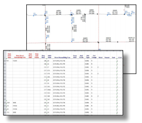
 Sidwell has developed workflows and software to ensure that the land management process is a streamlined process for our clients. Through our Address Manager software, organizations can simplify the maintenance of road centerline and address point layers while maintaining the accuracy which can be critical for emergency dispatch and response. Address Manager also supports integrated workflows within the land management process. Through Sidwell’s Parcel Builder-Administrator, parcel updates automatically trigger notifications to the address management department that there are new addresses to be created. This guarantees that the parcel and address information is in synch, reliable and ready for deployment across the enterprise.
Sidwell has always been an industry leader in providing GIS solutions and through partnerships with our clients and Bullberry Systems we have helped modernize the way in which E911 systems are utilized and deployed. We have worked with you to create more accurate systems that benefit the citizens of each organization. Having accurate and reliable data that can be accessed across the enterprise is in the best interest of each department, organization and the public. When data can be shared and utilized by everyone it increases the value of your GIS.