 Mel Obbink, Regional Account Manager
When your current technology changes, disrupting your current workflows and processes, what do you do? Washington County was faced with this dilemma when they learned that their current website was changing platforms. To avoid these issues, the county chose Sidwell to upgrade the mapping portion of the County Engineer’s ArcIMS-based website to a Portico, ArcGIS for Server-based GIS website.
The design of their current website was about to experience technology changes in which there would be no future ongoing support. It was also possible that the general public would not be able to access the County Engineer’s data via a mobile interface. The County Engineer had originally considered a separate website. However, the County Assessor’s office already had a site that provided portions of the information needed by the Engineers office, and it was determined that both offices could benefit from a sharing of information.
This collaboration benefits the Washington County taxpayers as well, since the County Engineer’s overall costs were lowered by almost $15,000 over a five year period. Additionally, the workload on County staff to maintain only one instance of a website rather than two would save on time and resources.
Combining of these websites provides one access point for data, whether it is general parcel data or a specific document (e.g. section corner monuments certificates). The documentation can be accessed and printed without requiring the end user to download a separate app to view the data.
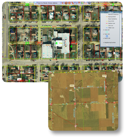 The county Engineer desired a GIS website with intuitive, user-friendly navigation, query, and reporting tools. The new Portico website delivers these in a powerful and efficient package. It features simple and familiar map navigation tools, and many basic and advanced search options. The user has the ability to easily browse the results, and have them exported in a variety of common formats. The site includes login access with separate portals for public and private users. The website also includes document management functionality.
The Engineer’s existing GIS data will be added to the public website. Data will be displayed at the request of the user, when the user is zoomed in to an appropriate map extent.
The Engineer also has the option of adding additional caches to their website. For example, the County has additional years of historic aerial photography that can be added to assist with tasks including land use studies, change detection, and environmental assessments.
By implementing Sidwell’s Portico GIS website, Washington County was able to realize many benefits. Through collaboration with the Assessor’s office, significant money was saved, and those savings will be passed along to the taxpayers. Public and private users will benefit from having an efficient and easy-to-use website from which to obtain critical information and make decisions.