Here are ArcGIS tips and tricks for desktop software (ArcMap) featuring useful user suggestions from Van O’Brien, Sidwell’s Director of Services and Solutions, and Richard Pascal at Ventura County, CA!
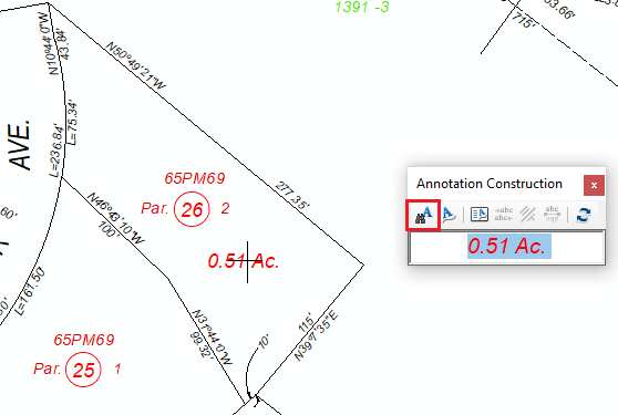
Find Annotation Tool
You can use the Find Annotation tool on the Annotation Construction box to click on a point, line of polygon and have attributes of the selected feature be the text that gets placed. For example, if you need to place an acreage annotation on the map and you have acreage as an attribute of a parcel polygon feature class:
⬙ Select the annotation symbol you want in the Create Features panel
⬙ Click on the Find Annotation tool
⬙ Click on the parcel and text will appear
⬙ Place the text
How does it know to select the right attribute?
The text that it gets off of the feature is based upon the default label expression that you can set in the Layer Properties. What this means is that all of the creativity you can put in a label expression to format one or more attributes will propagate to the annotations you create
What if I have overlapping features?
After clicking on a feature with the Find Annotation tool, you can press the W key to cycle through all of the possible features that are under your cursor.
Have Added Layers Not Visible by Default
Often times when you are setting up a map document in ArcGIS Desktop (ArcMap) you have to add in a large dataset. When the large dataset is loaded, you have to wait for the data to draw, and bailing out of the drawing process can be tedious. Usually this is avoided by adding a large layer when a map scale is small, which means that less data has to draw on screen, but this is problematic when the large layer is the first layer you bring in because the scale is not yet defined. However, a better method is an ArcMap setting that will not make newly added layers visible by default. This way you can load your layer, get to a reasonable map scale, and turn the layer on manually.
⬙ Go to Customize > ArcMap Options
⬙ Click on the General tab
⬙ Uncheck ‘Make newly added layers visible by default
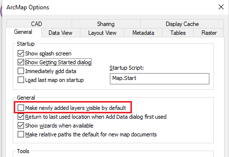
*Thank you to Richard Pascal at Ventura County, CA for this helpful tip/trick!